search
Sydney light rail map
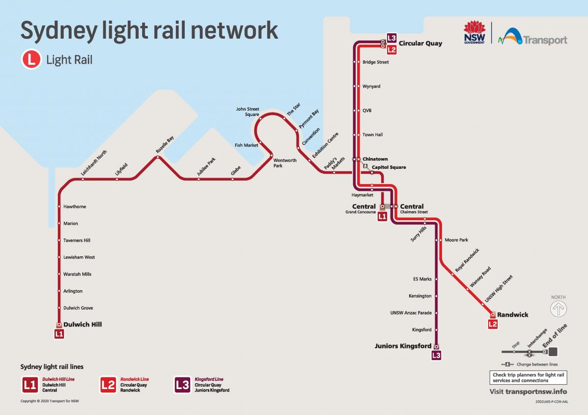
Light rail sydney map. Sydney light rail map (Australia) to print. Sydney light rail map (Australia) to download. The Metro Light Rail (formerly the Sydney Light Rail) is the only currently operating light rail line in Sydney. The line opened on 31 August 1997, mostly along the route of an unused goods railway line, to serve the redeveloped inner-city areas of Darling Harbour, Ultimo and Pyrmont, and was extended in 2000 to serve some of Sydney inner western suburbs as you can see in sydney light rail map. The line is owned by the NSW Government Metro Transport Sydney and operated under contract by Veolia. Running from Central Railway Station to the inner western suburb of Lilyfield, the route extends for 7.2 kilometres (4.5 mi), including 1.5 kilometres (0.93 mi) of on-street operation. There are 14 stops, including two interchanges to the Metro Monorail line and a station at The Star casino.
Most of the alignment of the Metro Light Rail Central to Lilyfield line had its origins as the Darling Harbour Goods Line as its shown in sydney light rail map. From the time when the Sydney Railway Company was formed in 1848, it had been the intention of the company to build a freight terminal at Darling Harbour. To this end, a railway line was constructed between the Sydney Railway Station (the predecessor to Central Railway Station) and Darling Harbour, which opened on 26 September 1855. This line was extended to Dulwich Hill via Lilyfield in 1922. With widespread use as a freight line throughout the early 20th century, the use of containers and the decentralisation of freight terminals in Sydney to places such as Port Botany and Chullora, Darling Harbour traffic was reduced considerably. The port was closed and the area redeveloped.
The Metro Light Rail uses German-design Variotram vehicles manufactured in Dandenong, Victoria by Adtranz (now Bombardier) as its mentioned in sydney light rail map. The trams are bi-directional and the Variotram design is modular and has been extended for the Sydney system. The capacity of the vehicles is 217 passengers, of which 74 are seated. On tests up to three trams have been coupled together allowing a maximum capacity of 600 passengers if required. The vehicles have a low floor (floor to rail level 300 millimetres / 12 inches) style and the bogies have no axles between the wheels and are powered with gearless hub motors. There are 7 trams currently in use. The articulated design allows a wide body car without overswing on curves and they have had their design weight reduced to compensate for the addition of climate-control air-conditioning equipment. The trams run on 750 volt direct current and each tram is fitted with three doors each side which have enhanced safety systems with obstacle detection interlocked with the traction system.
The Metro Light Rail uses its own ticketing system based on zones as you can see in sydney light rail map. Day and weekly tickets which also allow travel on the Metro Monorail are available. A "TramLink" ticket which allows travel on CityRail and the light rail is available from CityRail stations but is not sold on trams. From 27 June 2011 the Metro Light Rail has been partially integrated into the broader Sydney ticketing system. Tickets recognised on the light rail are all MyMultis, the Pensioner Excursion Ticket and Family Funday Sunday. The light rail will also be part of Sydney future electronic ticketing system. The integration led to a 30 to 40 percent increase in patronage on the line in the first months after introduction. On Friday, 23 March 2012 it was announced that the state government had bought Metro Transport Sydney, the owner of Sydney Light Rail and Monorail systems. The NSW Government says that this will allow them to face fewer obstacles in extending the network.


